ASEAN mula dibentuk dengan penubuhan sebuah organisasi dikenali sebagai Persatuan Asia Tenggara (Association of Southeast Asia atau ASA) yang dianggotai oleh Filipina, Malaysia dan Thailand pada tahun 1961. ASA merupakan asas kepada pembentukan ASEAN sekarang.
Akibat daripada pembentukan Malaysia pada 16 September 1963, pertikaian berlaku khususnya antara Indonesia dan Filipina yang menganggap pembentukan Malaysia sebagai satu bentuk penjajahan baru. Ini karena mereka mendakwa Sabah dan Sarawak merupakan sebagian daripada masing-masing Filipina dan Indonesia.
Oleh kerana pertikaian tersebut, munculnya slogan Ganyang Malaysia yang membawa kepada konfrentasi pada 1965-1966 oleh Indonesia.
Selepas tamat nya konfrantasi tersebut, semua negara-negara Asia Tenggara bersepakat untuk mewujudkan persepahaman untuk memberi ruang kepada semua negara-negara terbabit bersatu dalam perkara yang melibatkan kepentingan bersama.
Maka, pada 8 agustus 1967, lima pemimpin - Menteri Luar Indonesia, Filipina, Malaysia, Singapura dan Thailand ( Adam Malik, Narciso R. Ramos, Tun Abdul Razak, S. Rajaratnam, dan Thanat Khoman) - duduk bersama di dewan utama Jabatan Hal Ehwal Luar di Bangkok, Thailand dan menandatangani satu dokumen yang kini dikenali sebagai Deklarasi ASEAN.
Sabtu, 18 Februari 2012
Regions and Characteristics of Asia Continent !!!
Asia continent
is the largest continent with an area of ± 43,998,920 km ² and is the
densest population in the world with a territory covering 8.6% of the
earth’s surface.
Astronomically, the continent of Asia lies between ± 15 ° E – 180 ° east longitude and ± 75 ° N – 11 ° S with boundaries as follows:
Asia continent is divided into several areas, namely:
1. Central Asia
This area includes: Uzbekistan, Tajikistan, Turkmenistan, Kyrgyzstan, and Kazakhstan.
2. East Asia
This area includes
This area includes the Malay Peninsula, Indochina and islands in the Indian Ocean and Pacific Ocean. The countries included in this region are:
South Asia consists of:
Often referred to as the “Middle East” although the term is also sometimes used to refer to countries in North Africa.
West Asia can be subdivided to:
Asian continent has a characteristic or a characteristic that can distinguish it from other continents on the face of this earth. Here are some characteristics of the Asian Continent.
Asian Population distinguished on several major races and ethnic groups, as follows.
1. Kaukasut race (White Race)
Ras residents have in central Asia, West Asia, and in India (the tribes of Aryan / Hindu)
2. Negroid race (Black Race)
Ras residents have in phidelpia (Negrito), India (Dravidian), Eastern Indonesia (Papua), and Saudi Arabia (Nomad)
Astronomically, the continent of Asia lies between ± 15 ° E – 180 ° east longitude and ± 75 ° N – 11 ° S with boundaries as follows:
- the North bordering the Arctic Ocean (North Pole).
- the South bordering the Indian Ocean and the continent of Australia.
- the West with the European Continent and the Red Sea.
- East side is bordered by the Pacific Ocean.
Asia continent is divided into several areas, namely:
1. Central Asia
This area includes: Uzbekistan, Tajikistan, Turkmenistan, Kyrgyzstan, and Kazakhstan.
2. East Asia
This area includes
- Pacific Islands, Taiwan and Japan.
- North Korea and South Korea on the Korean peninsula.
- People’s Republic of China.
This area includes the Malay Peninsula, Indochina and islands in the Indian Ocean and Pacific Ocean. The countries included in this region are:
- in mainland Southeast Asia: Myanmar, Thailand, Laos, Cambodia and Vietnam.
- in the Islands of Southeast Asia: Malaysia, Philippines, Singapore, Indonesia, Brunei and Timor-Leste.
South Asia consists of:
- Himalayan countries: India, Pakistan, Nepal, Bhutan and Bangladesh
- Countries of the Indian Ocean: Sri Lanka and Maldives.
- The nickname for the Indian state is: Son of the Asian continent, Asia faces.
Often referred to as the “Middle East” although the term is also sometimes used to refer to countries in North Africa.
West Asia can be subdivided to:
- Countries in the Mediterranean island of Cyprus.
- Levant or Near East, including Syria, Jordan, Lebanon and Iraq.
- Arabian Peninsula, including Saudi Arabia, United Arab Emirates, Bahrain, Qatar, Oman, Yemen and Kuwait as well sometimes.
- Regional Caucasus, including Azerbaijan and Armenia.
- Overlay of Iran, which consists of Iran and parts of other countries.
Asian continent has a characteristic or a characteristic that can distinguish it from other continents on the face of this earth. Here are some characteristics of the Asian Continent.
- Continent of Asia is the largest and most populated continent.
- On the continent of Asia there are countries that have the largest population in the world, like China, India, and Indonesia.
- On the continent of Asia are the country’s largest oil producers, particularly the countries of the Arabian Peninsula region.
- Asian continent is where emerging and growing major religions in the world, such as the religion of Islam in Saudi Arabia, Christianity and Catholicism in Jerusalem, Hinduism and Buddhism in India, and the religion of Confucianism in the PRC.
- On the continent of Asia there are many historical buildings, it can even be classified as the Seven Wonders of the World, namely the Great Wall in China, the Kaaba in Mecca (Saudi Arabia), Taj Mahal in India, and Indonesia’s Borobudur temple.
- The region is dominated by a string of mountains that extends to the northeast.
- Mountains consist of highlands, savannah, steppe and concatenated with the desert and Gobi desert, so the profile is relatively arid region
- The landscape consists of low plains, and there is a large river which empties into the east coast
- There is a plateau in the south east coast which is a connection from the highlands of Yunnan
- western China (Tibet) has high mountains of the Himalayas connection
- China’s Gobi desert north of there (overgrown steppe and savannah)
- In the Japanese archipelago, is dominated by a series of active volcano, in between his swift-flowing river flow (for hydropower)
- Meeting young mountain sirkum Pacific and Mediterranean
- Many active volcanoes (Philippine and Indonesia)
- Many strands of inactivity mountainous
- A stretch of lowlands located in the flow path and large river deltas (Mekong River, Irrawadi River, Rivers added, and some rivers in Indonesia)
- Dominated by young Himalayan Mountains.
- There is a plateau Dean in the middle of the Indian peninsula, stretching the mountains of Western Ghats and Eastern Ghats
- In the central plains of Sri Lanka there
- Between the Himalayas and the highlands of Dean lying plains of the Ganges flow
- Consists of the plateau savanna-covered plateaus and steppe
- Deserts lie in Arab peninsula (Arabian desert and the Sinai Desert)
- In the region of Asia Minor (minor) is a high mountain with very varied relief
- On the sidelines of the mountains there are strands of large rivers and small rivers like the Euphrates and the Kizil River.
Asian Population distinguished on several major races and ethnic groups, as follows.
1. Kaukasut race (White Race)
Ras residents have in central Asia, West Asia, and in India (the tribes of Aryan / Hindu)
2. Negroid race (Black Race)
Ras residents have in phidelpia (Negrito), India (Dravidian), Eastern Indonesia (Papua), and Saudi Arabia (Nomad)
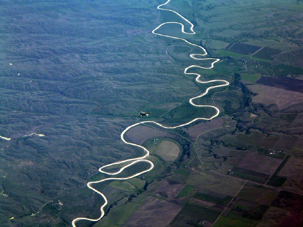
10 of the longest river !
1. Nile River in Africa has a 6650 kilometer long

The Nile (Arabic: an-nil النيل or Egyptian / Coptic iteru), in Africa, is one of the two longest rivers on Earth. Nile River flows along the 6650 km or 4132 miles and split no less than nine countries are: Ethiopia, Zaire, Kenya, Uganda, Tanzania, Rwanda, Burundi, Sudan and Egypt, of course. Because of the Nile has the same meaning role in Egyptian history (especially ancient Egypt) is identical with the Egyptian Nile. Battle of the Nile has a very important role in civilization, life and history of the Egyptians thousands of years ago. One contribution of the Nile is its ability to produce fertile soil as a result of sedimentation along the river basin. With the fertile soil makes the inhabitants of Egypt to develop its agriculture and developing the Egyptian civilization for thousands of years ago.
2. Amazon River in South America has a 6400 kilometer long
3. Yangtze / Chang Jiang in China's State 6300 kilometers in length
The length of the Yangtze River or (Hanzi: 长江, Hanyu Pinyin: Changjiang, English: Long River, Yangtze River) is the longest river in China and in Asia. In the world, Yangtze River is the third longest river. The river became the southern boundary of ancient Chinese culture that lies between the Yellow River in the north and the Yangtze River in the south.
This river is known as the Yangtze River (Hanyu Pinyin: Yangzi) due to an incorrect understanding of the missionaries at first. Yangtze River (Hanzi: 杨子江) refers only to the lower reaches of Yangtze River, but because it is first heard by a Westerner, it is used to represent the entire Yangtze River Yangtze River4.Mississippi River - Missouri is located in North America has a length of 6275 kilometer
The Mississippi River is the river in the U.S.. Is one of the longest river in the world and is the second longest river in the United States. Has a length of 3.734 km (2.320 mi) and originated in Lake Itasca in Minnesota and lead to the Gulf of Mexico.
The name "Mississippi" comes from a Native American language meaning "father of waters."
Spring is in the state of Mississippi Minnesota, near the border with Canada. Mississippi flows south through the middle of the U.S.. Flowing through the state of Wisconsin, Iowa, Illinois, Missouri, Kentucky, Tennessee, Arkansas, and Mississippi.
Mouth of the Mississippi is in the state of Louisiana, the southern city of New Orleans. Mississippi empties into the Gulf of Mexico.
Mississippi has many tributaries. Mississippi watershed covers most of the U.S.. This means that the Mississippi and its tributaries flow in most U.S. states.
Some of the most important tributary of the Mississippi are (listed from the spring to the mouth of the river):5. River Yenisei - Angara - Selenga in Russia and Mongolia have a 5539 kilometer long

6. Yellow River / Huang Ho in China continent of Asia has a length of 5464 kilometers

Yellow River (Hanzi: 黄河, Hanyu Pinyin: Huanghe listen, Wade-Giles: Hwangho, English: Yellow River) is an important river in northern China at the center of Chinese culture together with Long River (Yangtze) to the south .
With a length of 5464 km, this river is the second longest river in China after the Yangtze River. 7. River Ob - Irtysh was in Europe and Asia have a 5410 kilometer long

8. Africa's Congo River is 4700 kilometers in length

Congo River (also known as Zaire River) is the largest river in West-Central Africa. This river has a length of about 4,700 km, making it the second largest river in Africa (after the Nile). This river flows through the largest rainforest in the world, [1]. Kongo's name comes from the Kingdom of Kongo. From 1971 to 1997, the government called it the Zaire River Zaire.
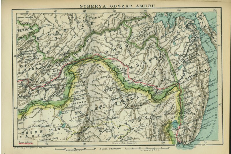
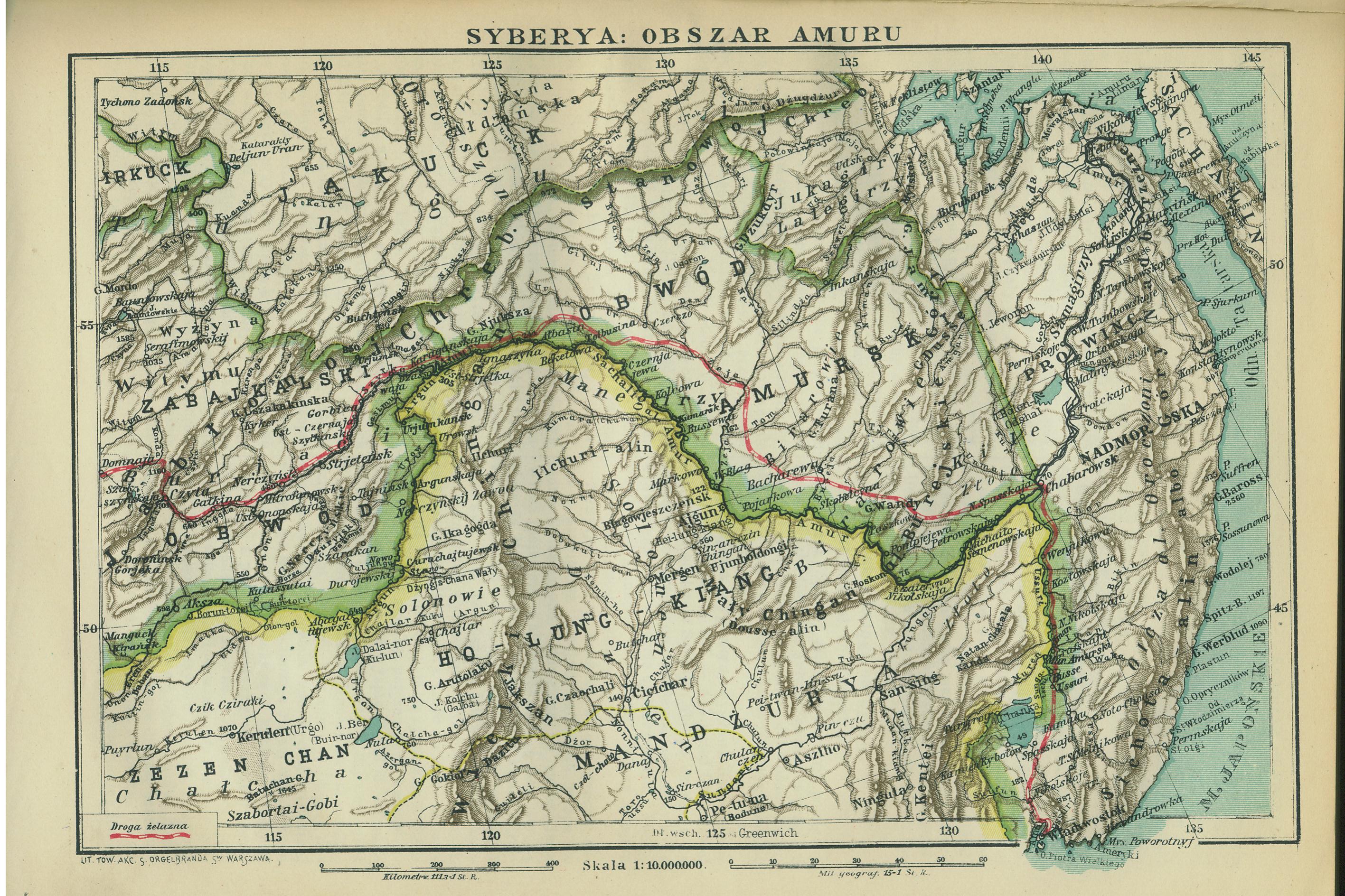
9. Amur river in Europe and Asia has a 4444 kilometer long
10. Lena river in the Continent of Europe (Russia) has a length of 4400 km

Lena River is the 10th largest river in the world. This river is located in Siberia. Length of 4400 km (2734 miles). This river comes down from the Arctic Sea to Mount Baikal.
The Nile (Arabic: an-nil النيل or Egyptian / Coptic iteru), in Africa, is one of the two longest rivers on Earth. Nile River flows along the 6650 km or 4132 miles and split no less than nine countries are: Ethiopia, Zaire, Kenya, Uganda, Tanzania, Rwanda, Burundi, Sudan and Egypt, of course. Because of the Nile has the same meaning role in Egyptian history (especially ancient Egypt) is identical with the Egyptian Nile. Battle of the Nile has a very important role in civilization, life and history of the Egyptians thousands of years ago. One contribution of the Nile is its ability to produce fertile soil as a result of sedimentation along the river basin. With the fertile soil makes the inhabitants of Egypt to develop its agriculture and developing the Egyptian civilization for thousands of years ago.
2. Amazon River in South America has a 6400 kilometer long
Amazon River (Spanish: Río Amazonas, Portuguese: Rio Amazonas) is a river in South America which is the world's second longest river - the Nile River is the longest in Africa. The Amazon River has the greatest total flow of any river, carrying more than the Mississippi River, the Nile, and Yangtze combined. Amazon also has the largest peraliran system of the entire river system. Although the Nile the longest river, but Amazon could be considered "powerful" (as seen from the amount of water flowing per second).
Amount of fresh water being released into the Atlantic Ocean is enormous: 184 000 m³ per second (6.5 million ft ³) in the rainy season. Amazon flow is one-fifth of the total fresh water into the sea around the world. In sea water near the river has a low salinity up to hundreds of miles away.
The main river (usually has a width of one to six miles) can be passed to large ocean steamers to Manaus, nearly 800 miles up the river from its mouth. Smaller ships weighing 3,000 tons [1] and 5.5 m (18 ft) draft [2] can reach as far as Iquitos, 3700 km (2,300 miles) from the sea. Smaller riverboats can reach 780 km (486 miles) further up Achual Point. Through from there, only small boats can go up to Pongo de Manseriche, above Achual Point.
This river takes water from the coordinates 5 ° N to 20 ° latitude. The most distant sources are found in inter-Andean plateau, a short distance away to the Pacific Ocean, and after a distance of 7200 km (4,800 miles) through the interior of Peru and across Brazil, he entered the Atlantic Ocean at the Equator
This river is known as the Yangtze River (Hanyu Pinyin: Yangzi) due to an incorrect understanding of the missionaries at first. Yangtze River (Hanzi: 杨子江) refers only to the lower reaches of Yangtze River, but because it is first heard by a Westerner, it is used to represent the entire Yangtze River Yangtze River4.Mississippi River - Missouri is located in North America has a length of 6275 kilometer
The Mississippi River is the river in the U.S.. Is one of the longest river in the world and is the second longest river in the United States. Has a length of 3.734 km (2.320 mi) and originated in Lake Itasca in Minnesota and lead to the Gulf of Mexico.
The name "Mississippi" comes from a Native American language meaning "father of waters."
Spring is in the state of Mississippi Minnesota, near the border with Canada. Mississippi flows south through the middle of the U.S.. Flowing through the state of Wisconsin, Iowa, Illinois, Missouri, Kentucky, Tennessee, Arkansas, and Mississippi.
Mouth of the Mississippi is in the state of Louisiana, the southern city of New Orleans. Mississippi empties into the Gulf of Mexico.
Mississippi has many tributaries. Mississippi watershed covers most of the U.S.. This means that the Mississippi and its tributaries flow in most U.S. states.
Some of the most important tributary of the Mississippi are (listed from the spring to the mouth of the river):5. River Yenisei - Angara - Selenga in Russia and Mongolia have a 5539 kilometer long
6. Yellow River / Huang Ho in China continent of Asia has a length of 5464 kilometers
Yellow River (Hanzi: 黄河, Hanyu Pinyin: Huanghe listen, Wade-Giles: Hwangho, English: Yellow River) is an important river in northern China at the center of Chinese culture together with Long River (Yangtze) to the south .
With a length of 5464 km, this river is the second longest river in China after the Yangtze River. 7. River Ob - Irtysh was in Europe and Asia have a 5410 kilometer long
8. Africa's Congo River is 4700 kilometers in length
Congo River (also known as Zaire River) is the largest river in West-Central Africa. This river has a length of about 4,700 km, making it the second largest river in Africa (after the Nile). This river flows through the largest rainforest in the world, [1]. Kongo's name comes from the Kingdom of Kongo. From 1971 to 1997, the government called it the Zaire River Zaire.
9. Amur river in Europe and Asia has a 4444 kilometer long
10. Lena river in the Continent of Europe (Russia) has a length of 4400 km
Lena River is the 10th largest river in the world. This river is located in Siberia. Length of 4400 km (2734 miles). This river comes down from the Arctic Sea to Mount Baikal.
info pantai remis !
Pantai Remis [班台] is a coastal town in Manjung, Perak, Malaysia. It is situated in between Simpang (near Taiping) and Sitiawan. Pantai Remis
is a commercial district that serves as the heartland for the
surrounding towns as far north as Terong on Highway A101, to the south
to Segari on Highway 60; to the south-east to Kampong Baru Sungai Batu,
Kampong Batu Dua Belas, Kampong Melayu and Changkat Keruing on Highway
A12. Rubber, palm oil, rice, sugar cane, fishing are the major
industries in this town.
Pantai Remis is one of the towns which has an independent Chinese secondary school. Yik Ching High School is a community funded non-for-profit secondary school. It also consists a government funded national public secondary school -- Sekolah Menengah Kebangsaan (SMK) Pantai Remis. Yik Ching High School 育青中学 accepts students from SRJK (Chinese)Tit Bin (Semi-government funded Primary School) and other Chinese primary schools. SMK Pantai Remis accepts students from SRJK (Chinese) Tit Bin and Sekolah Rendah Kebangsaan (Government funded National Primary School).
Sekolah Menengah Dato' Idris (Dato' Idris Secondary School) that is located in the nearby Pengkalan Baru town has been the only national public secondary before Sekolah Menengah Kebangsaan Pantai Remis was established in Taman Bintang (Star Garden), Pantai Remis.
The town was founded in the late 1940s. The name is probably derived from a type of Sea shell - Remis, which is a greyish shell and is easily crushed.It lies on the estuary of the Bruas River, it is believed that the once prosperous Hindu Kingdom of Gangga Negara's Port of entry was here. The Bruas tree which is no longer found in Bruas is still growing in Pengkalan Bahru, a sleepy village 5 km from Pantai Remis.
It is also the location of the Third Beach Tin mine landslide filmed in 1993. Starting from Pantai Remis, stretching southward, the coast has up to seven beautiful sandy beaches before The Seventh Beach Damai Laut Resort. Second Beach (Teluk Akuan) is frequented by the locals via fishing boats. The Third Beach is the exact location of the landslide. The Forth Beach was a beautiful beach and had been extensively mined and later transformed into an independently run power genaration plant. The plant is operated by Malakoff. The Fifth Beach survived from the onslaught of local tin mining industry and was saved by two government related projects built at the beach front.
What Is planet ?
what is that planets ?
The planets were thought by Ptolemy to orbit the Earth in deferent and epicycle motions. Though the idea that the planets orbited the Sun had been suggested many times, it was not until the 17th century that this view was supported by evidence from the first telescopic astronomical observations, performed by Galileo Galilei. By careful analysis of the observation data, Johannes Kepler found the planets' orbits to be not circular, but elliptical. As observational tools improved, astronomers saw that, like Earth, the planets rotated around tilted axes, and some shared such features as ice caps and seasons. Since the dawn of the Space Age, close observation by probes has found that Earth and the other planets share characteristics such as volcanism, hurricanes, tectonics, and even hydrology.
Planets are generally divided into two main types: large, low-density gas giants, and smaller, rocky terrestrials. Under IAU definitions, there are eight planets in the Solar System. In order of increasing distance from the Sun, they are the four terrestrials, Mercury, Venus, Earth, and Mars, then the four gas giants, Jupiter, Saturn, Uranus, and Neptune. Six of the planets are orbited by one or more natural satellites. Additionally, the Solar System also contains at least five dwarf planets[3] and hundreds of thousands of small Solar System bodies.
Since 1992, hundreds of planets around other stars ("extrasolar planets" or "exoplanets") in the Milky Way Galaxy have been discovered. As of February 14, 2012, 760 known extrasolar planets (in 609 planetary systems and 100 multiple planetary systems) are listed in the Extrasolar Planets Encyclopaedia, ranging in size from that of terrestrial planets similar to Earth to that of gas giants larger than Jupiter.[4] On December 20, 2011, the Kepler Space Telescope team reported the discovery of the first Earth-sized extrasolar planets, Kepler-20e[5] and Kepler-20f,[6] orbiting a Sun-like star, Kepler-20.[7][8][9] A 2012 study, analyzing gravitational microlensing data, estimates an average of at least 1.6 bound planets for every star in the Milky Way.[10]
Langganan:
Postingan (Atom)